(News) - Non Nước Cao Bằng UNESCO Global Geopark is an exceptional area in which it is possible to explore the history of planet Earth for more than 500 million years. It’s also a land of tangible and intangible cultural heritage sites. Bùi Quỳnh Hoa explores.
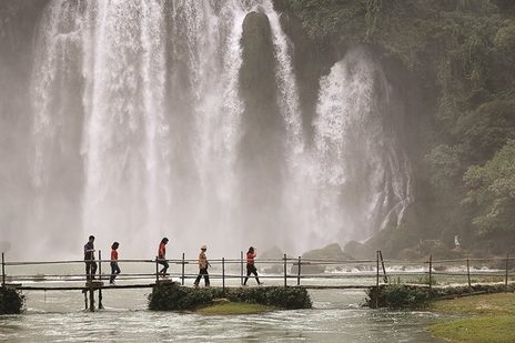
NATURAL BEAUTY: Bản Giốc Waterfall on Quây Sơn River at Đàm Thủy Commune, Trùng Khánh District, Cao Bằng Province is the fourth largest waterfall in the world at an international border, after Iguazu Falls between Brazil and Argentina, Victoria Falls between Zambia and Zimbabwe, and Niagara Falls between the US and Canada. VNS Photos Đoàn Tùng.
"Nàng về nuôi cái cùng con
"Để anh đi trảy nước non Cao Bằng
(Go back home and take care of our children and our mother
Let me go and have a venture in the majestic nature of Cao Bằng)
This popular Vietnamese folk song explains that Cao Bằng is a magnificent land filled with attractions. One such mystical place is Non Nước Cao Bằng Geopark, one of the most impressive attractions of the province, which has been recognised as a UNESCO global geopark, the second of its kind in Việt Nam.
Located in the north of Việt Nam, 300km from Hà Nội, Non Nước Cao Bằng UNESCO Global Geopark covers 3,000sq.km. It covers six districts of Hà Quảng, Trà Lĩnh, Quảng Yên, Trùng Khánh, Hạ Lang, Phục Hòa, and part of Hoà An, Nguyên Bình and Thạch An districts. The geopark is home to nine ethnic groups including Tày, Nùng, Mông, Dao and Sán Chay.
The geopark is an exceptional territory which offers insights into the history of our planet across more than 500 million years through protected sites. Fossils, marine sediment, volcanic and plutonic rocks and minerals are witness to the remarkable evolution and changes of our planet, and they constitute an exceptional geological heritage.
It is also a land of tangible and intangible cultural heritage sites and special historical monuments. The area is also well-known for its high biological diversity with abundant endemic plant and animal species and ecosystems.
There are three main routes to explore the geopark, including going to the east to experience traditional cultures, north to see history and freedom, and west to experience Phia Oắc, the mountain of transformations.
Wonderland to the east
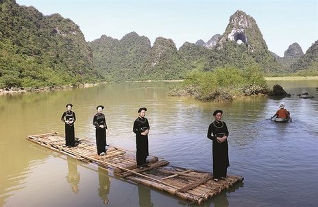
My friends and I started the journey on an autumn day. The path to the route east is winding with one side green limestone mountains, and the other an abyss covered by white mist. Little wild flowers in many colours in the wind, fresh cool air, yellow sunlight, imposing scenes, and ethnic Tày girls in black costumes working happily in the rice fields created a painting of a peaceful rural life, harmoniously blended with nature.
Mã Phục Pass was the first site on our route.
Located in Cao Xuyên Village, Quốc Toản Commune, Trà Lĩnh District, more than 3.5km long at an altitude of 700m above sea level, the pass is one of the most beautiful in Cao Bằng.
Trần Văn Tân, head of the Institute of Geosciences and Natural resources, Ministry of Environment and Natural Resources, said the pass winds between two high limestone mountain ranges and constitutes, at its bottom, an exceptional geosite. Here, in contact with limestone (white rock) can be seen a blackish green rock with rounded shape – the so-called pillow basalt.
“Besides the exceptional geological interest, Mã Phục is also a place of intangible heritage,” said Chu Thị Vinh, deputy head of Trà Lĩnh District.
“According to legend, in the 11th century, a leader of the Nùng people named Nùng Trí Cao led local people to fight against the Chinese Song army from the north. Once returning from a patrol along the border, at Quốc Toản Commune of present day Trà Lĩnh District, he faced this high, winding and steep pass, and his horse was crippled and could not continue. The mountain was since named Án Lại, literally meaning to stop, and the pass was named Mã Phục, literally meaning a kneeling horse,” Vinh said.
MAJESTIC: Mountain Angel Eye or Phia Piot in Tày language means a mountain with a through-going hole, which is 50m in diameter and 50m high above the lake.
Leaving Mã Phục Pass, we reached Angel Eye Mountain in Quốc Toản Commune, Trà Lĩnh District.
Angel Eye Mountain or Phia Piot in Tày language means a mountain with a through-going hole, which is 50m in diameter and 50m above the lake.
After a walk of about 15 minutes, we saw Tày people in Bản Danh Hamlet with stilt houses, yin and yang tiled roofs, stone fences, paddy fields of rice and maize, water buffaloes and cows, and the surrounding green and mature karst landscape. This helped us relax and recover from our daily stresses.
At the end of the route going to the east, we reached Bản Giốc Waterfall, a must-see place in Cao Bằng.
Located on the Quây Sơn River at Đàm Thủy Commune, Trùng Khánh District, Bản Giốc Waterfall is the fourth largest waterfall in the world at an international border, after Iguazu Falls between Brazil and Argentina, Victoria Falls between Zambia and Zimbabwe, and Niagara Falls between the US and Canada.
Trần Thị Xuân Quỳnh, member of the management board of the Non Nước Cao Bằng UNESCO Global Geopark, said Bản Giốc Fall is approximately 300 wide and 35m high, with three cascades. It runs between Việt Nam and China.
Lots of foreign visitors have come here, along with locals.
“I’ve heard about Bản Giốc Waterfall, but it’s more amazing to witness with my eyes,” said Guy Martini from Italy.
“It’s great to see thick forest covering both up and downstream with frothy water, and lively human activities here. It brings me an unforgettable experience,” he said.
Historical experience to the north
We explored historical sites the next day.
From Cao Bằng City, we headed north, passing vast fragrant paddy rice fields which were in harvest time, to visit historical sites that tell of the revolutionary life of President Hồ Chí Minh after he came back to Việt Nam on January 28, 1941.
PEACEFUL: The jade, tranquil Lenin Stream which softly and peacefully meanders at the foot of the rampart is worth a visit.
The jade tranquil Lenin Stream which softly and peacefully meanders at the foot of the rampart – like Karl Marx Mountain, is worth a visit.
Crossing a small bridge, walking 15 minutes and then climbing up for about 50 steps, both natural and artificial, we reached Cốc Bó Cave, President Hồ Chí Minh's shelter during his time in Pác Bó.
The small, almost dry and quiet reserve, though still having a second entrance, was badly damaged during the border war with China and has been partly restored. The stone bed where President Hồ used to sleep is still there. I wondered how could he live such a simple and sparse, yet still optimistic and heroic life.
Nguyễn Hải Long, 19, from Hà Nội had the same feeling.
“This is the first time I have visited Cao Bằng. Although the way from Hà Nội to the province is so hard, I don’t regret my decision, especially when I visited Lenin Stream, Karl Marx Mountain and Cốc Bó Cave where President Hồ lived and worked. I admire him so much,” Long said.
It turned to the end of the trip. Everybody was tired. But there was still a big challenge – the historic border landmark No 108, where President Hồ Chí Minh made his first steps back to his home country after more than 30 years travelling abroard seeking ways for national salvation.
If I accepted the challenge, we would have to climb up for 1,000m to the ridge of the mountain range to look on Chinese territory and touch the historic border landmark. I hate climbing so much and had never climbed so high. But we didn’t give up.
On the way to the top, many times I thought I could not do it. Some others had the same thoughts as me. But finally, we overcame our doubts and did it, giving us an experience we will never forget.
Mountain of transformations to the west
After recovering with some local food and a good sleep, we headed west on the next day to experience Phia Oắc, the mountain of transformations.
The route was a highlight, with many attractive sights including Phai Khắt Post, beewax brocade by Dao Tiền people, Phia Đén salmon farm, Bản Ổ and Lũng Mười tungsten mines, Phia Oắc-Phia Đén National Park, Trần Hưng Đạo Forest Special National Monument, and Kolia tea farm.
Lý Thị Thu Thủy, a tourist guide, said evidences of many processes and events that have contributed to the area’s transformations are showed clearly through volcanic activities, changes in climate, ecosystems and biodiversity with altitude, and especially changes related to the legendary General Võ Nguyên Giáp and his army in the early years of the August Revolution in 1945.
“Among those, Trần Hưng Đạo Forest is a highlight. A primitive forest covering more than 200ha, it is the place where the Việt Nam Liberation Army were established on December 22, 1944 (the precursor to the present Việt Nam People’s Army).
“This is a living museum of space and time, as it preserves places and objects that are related to a very important historical period of Việt Nam's revolution. It is closely associated with the life and activities of General Võ Nguyên Giáp, who was the outstanding protégé of President Hồ Chí Minh, and the Great Brother of the Việt Nam People’s Army.
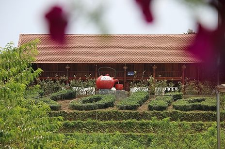
CUPPA COMING UP: Located in Non Nước Cao Bằng UNESCO Global Geopark, Kolia tea farm is a highlight of the route to the west.
“This is also an ideal place for ecotourism and research,” Thủy added.
Kolia tea farm is another highlight for the route to the west.
Located in the western route of Non Nước Cao Bằng UNESCO Global Geopark, Kolia tea farm is an active geopark partner.
Phia Đén in Nguyên Bình District is considered heaven as it is 1,300m above sea level. We took lots of pictures here with majestic mountains and forest, full of sunshine and floating white clouds.
Phia Đén tea is the farm’s speciality. The production follows a clean model, which not only helps the ecosystem, but also creates jobs for local people. It’s sold widely in local and international markets, even in China.
Promotion strengthening
To make best use of the advantages of Cao Bằng, the management board of Non Nước Cao Bằng Geopark focuses on communication and promotion activities to raise awareness of communities in the area; signing deals with the Institute of Geo-sciences and Mineral Resources, and international experts on the development of the geopark; and strengthening international co-operation with other UNESCO global geoparks to introduce Cao Bằng to the world.
Deputy Chairman of Cao Bằng Province’s People’s Committee, Nguyễn Trung Thảo, said that last year, the province welcomed more than 1.2 million visitors, which brought the province a turnover from tourism of VNĐ400 billion (US$17.3 million).
This is a good sign but the province also plans to invest in transportation infrastructure, strengthen border trade, and develop tourism as the province’s key industry.
The three experience routes give visitors a chance to explore the geopark, as well as local people here. Each of these routes can be visited, with a guide, and will leave a unique and unforgettable experience.
Source: VNS
VNQD